GEBCO bathymetric NetCDF Database
Please refer to official GEBCO documentation for further info on this NetCDF file.
World Ocean Atlas 2005 and 2009 SSP Databases
These databases contain monthly, seasonal and annual average of sound speed profiles, calculated with the TEOS-10 exact formula, and based on the depth, temperature and salinity provided by the World Ocean Atlas. The available resolution is 1° x 1°. Data are provided at standard depths [m] :
0, 10, 20, 30, 50, 75, 100, 125, 150, 200, 250, 300, 400, 500, 600, 700, 800, 900, 1000, 1100, 1200, 1300, 1400, 1500, 1750, 2000, 2500, 3000, 3500, 4000, 4500, 5000, 5500.
The NetCDF files have been generated with NetCDF classic and are compatible with NetCDF4 library. Each NetCDF file has the following dimensions:
- latitude: 180 values, from 89.5° to -89.5°
- longitude: 360 values, from -179.5° to 179.5°
- depth: 33 values (standard depths).
Each NetCDF file has the following variables description:
-
float ssp(latitude, longitude, depth) ;
ssp:units = "m/s" ; -
float latitude(latitude) ;
latitude:units = "decimal degrees" ; -
float longitude(longitude) ;
longitude:units = "decimal degrees" ; -
short depth(depth) ;
depth:units = "m" ;
World Ocean Atlas 2001, 2013, 2018 and 2023 SSP Databases
These databases contain monthly, seasonal and annual average of sound speed profiles, calculated with the TEOS-10 exact formula, and based on the depth, temperature and salinity provided by the World Ocean Atlas. The available resolution is 0.25° x 0.25°. Data are provided at standard depths [m] :
0, 10, 20, 30, 50, 75, 100, 125, 150, 200, 250, 300, 400, 500, 600, 700, 800, 900, 1000, 1100, 1200, 1300, 1400, 1500, 1750, 2000, 2500, 3000, 3500, 4000, 4500, 5000, 5500.
The databases require NetCDF4 + HDF5 support. Each NetCDF4 file has the following dimensions:
- latitude: 720 values, from -89.875° to 89.875°
- longitude: 1440 values, from -179.875° to 179.875°
- depth: 33 values (standard depths).
Each NetCDF4 file has the following variables description:
-
float ssp(latitude, longitude, depth) ;
ssp:units = "m/s" ; -
float latitude(latitude) ;
latitude:units = "decimal degrees" ; -
float longitude(longitude) ;
longitude:units = "decimal degrees" ; -
short depth(depth) ;
depth:units = "m" ;
DECK41 Sediment NetCDF Database
The DECK41 collection contains surficial sediment descriptions for over 36,000 seafloor samples worldwide. Data include collecting source, ship, cruise, sample id, latitude/longitude, date of collection, water depth, sampling device, dominant lithology, secondary lithology, and a brief description of the surficial sediment at the location
The NetCDF files provided indexes the dominant and secondary lithology for geoacoustical purposes. These values are represented by an unsigned integer number between 0 and 11:
- Coarser than sand
- Sand
- Silt
- Clay
- Ooze
- Mud
- Rocks, Rocks fragment
- Organic material (shell, peat, wood, coral, etc.)
- Nodules, slab or concretions (manganese, phosphate, iron, glauconite)
- Hard bottom
- NO_VALUE
These values are collected in three different databases, and they come in different database format versions.
DECK41 NetCDF database
This database contains all the valid DECK41 coordinates, quantized as per data formats below.
- See also
- woss::SedimDeck41CoordDb
V1 Data Format
This database has a NetCDF legacy format, with resolution of 0.016° x 0.016°, with the following dimension:
- a single index dimension covering:
- latitude: 10801 values, from 90.0° to -90.0°
- longitude: 21601 values, from -180° to 180.0°
- spacing: 0.0166666666666667°
- total indexes (xysize) 233312401
This NetCDF file has the following variables description:
-
byte seafloor_main_type(xysize) ;
seafloor_main_type:units = "DECK 41 type" ;
seafloor_main_type:valid_min = 0 ;
seafloor_main_type:valid_max = 9 ;
-
byte seafloor_secondary_type(xysize) ;
seafloor_secondary_type:units = "DECK 41 type" ;
seafloor_secondary_type:valid_min = 0 ;
seafloor_secondary_type:valid_max = 9 ;
V2 Data Format
This database has a NetCDF4 format, with resolution of 0.016° x 0.016°, with the following dimensions:
- latitude: 10800 values, from -89.9833333333333333° to 89.9833333333333333°
- longitude: 21600 values, from -179.9833333333333333° to 179.9833333333333333°
The spacing is 0.0166666666666667° This NetCDF file has the following variables description:
-
byte seafloor_main_type(latitude, longitude) ;
seafloor_main_type:units = "DECK 41 type" ;
seafloor_main_type:valid_min = 0 ;
seafloor_main_type:valid_max = 9 ;
-
byte seafloor_secondary_type(latitude, longitude) ;
seafloor_secondary_type:units = "DECK 41 type" ;
seafloor_secondary_type:valid_min = 0 ;
seafloor_secondary_type:valid_max = 9 ;
DECK41 marsden square NetCDF database
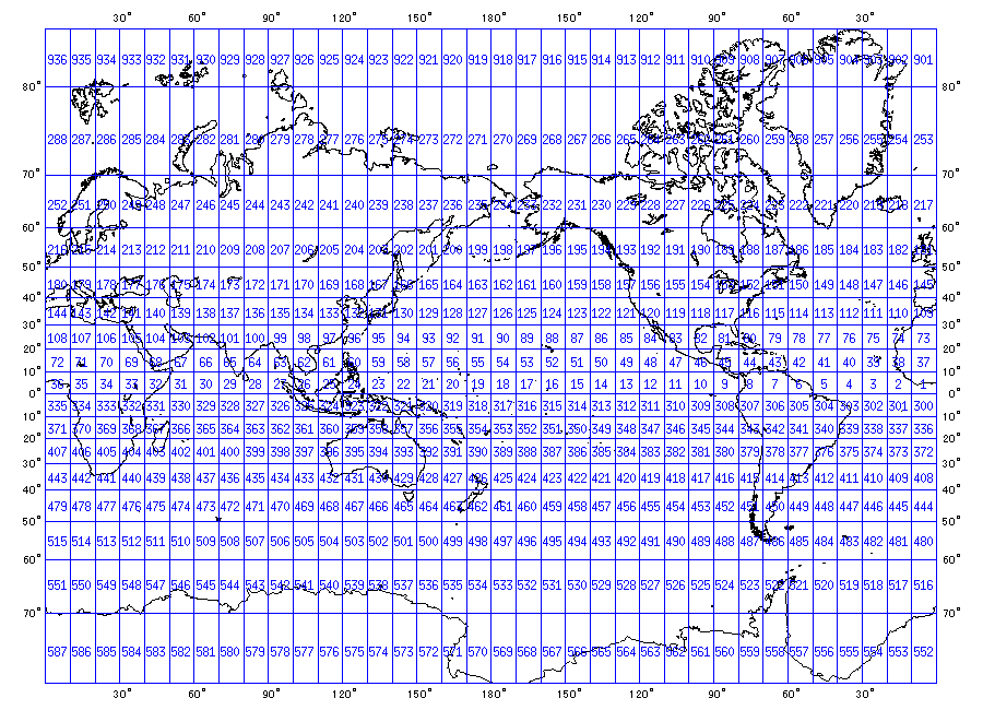
This database covers all marsden squares. Lithology data of a marsden square are a representative set of all original data for that particular square.
- See also
- woss::SedimDeck41MarsdenDb
V1 Data Format
The database is in NetCDF legacy format. It has a single dimension:
- marsden_square: 937 values
This NetCDF file has the following variables description:
-
byte seafloor_main_type(marsden_square) ;
seafloor_main_type:units = "DECK 41 type" ;
seafloor_main_type:valid_min = 0 ;
seafloor_main_type:valid_max = 9 ;
-
byte seafloor_secondary_type(marsden_square) ;
seafloor_secondary_type:units = "DECK 41 type" ;
seafloor_secondary_type:valid_min = 0 ;
seafloor_secondary_type:valid_max = 9 ;
V2 Data Format
The database is in NetCDF4 format. It has a single dimension:
- marsden_square: 936 values
This NetCDF file has the following variables description:
-
byte seafloor_main_type(marsden_square) ;
seafloor_main_type:units = "DECK 41 type" ;
seafloor_main_type:valid_min = 0 ;
seafloor_main_type:valid_max = 9 ;
-
byte seafloor_secondary_type(marsden_square) ;
seafloor_secondary_type:units = "DECK 41 type" ;
seafloor_secondary_type:valid_min = 0 ;
seafloor_secondary_type:valid_max = 9 ;
DECK41 marsden coordinates NetCDF database
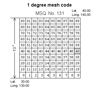
This database covers all marsden coordinates squares (marsden square, marsden one degree square). Lithology data of a marsden coordinates square are a representative set of all original data for that particular set of marsden coordinates.
- See also
- woss::SedimDeck41MarsdenOneDb
V1 Data Format
The database is in NetCDF legacy data format. It has two dimensions:
- marsden_square: 937 values
- marsden_one_degree: 100 values
The database has the following variables description:
-
byte seafloor_main_type(marsden_square, marsden_one_degree) ;
seafloor_main_type:units = "DECK 41 type" ;
seafloor_main_type:valid_min = 0 ;
seafloor_main_type:valid_max = 9 ;
-
byte seafloor_secondary_type(marsden_square, marsden_one_degree) ;
seafloor_secondary_type:units = "DECK 41 type" ;
seafloor_secondary_type:valid_min = 0 ;
seafloor_secondary_type:valid_max = 9 ;
V2 Data Format
The database is in NetCDF4 data format. It has two dimensions:
- marsden_square: 936 values
- marsden_one_degree: 100 values
The database has the following variables description:
-
byte seafloor_main_type(marsden_square, marsden_one_degree) ;
seafloor_main_type:units = "DECK 41 type" ;
seafloor_main_type:valid_min = 0 ;
seafloor_main_type:valid_max = 9 ;
-
byte seafloor_secondary_type(marsden_square, marsden_one_degree) ;
seafloor_secondary_type:units = "DECK 41 type" ;
seafloor_secondary_type:valid_min = 0 ;
seafloor_secondary_type:valid_max = 9 ;
DECK41 Sediment selection logic
woss::SedimDeck41Db uses all three NetCDF database for its Sediment query process:
- it first queries the woss::SedimDeck41CoordDb first with provided coordinates;
- if a suitable result is not found, then it continues the search in woss::SedimDeck41MarsdenOneDb, e.g. in the corrispondant marsden one degree square associated with given coordinates;
- if even this step fails, it finally searches woss::SedimDeck41MarsdenDb for the marsden square associated.
- See also
- woss::SedimDeck41Db, woss::Deck41TypeTests
DECK41 geoacoustic parameters
A thorough analysis has been done and is still in process to correctly provide geoacoustical parameters for DECK41 lithology data. The available categories are:
- Coarser than sand - woss::SedimentGravel
- Sand - woss::SedimentSand
- Silt - woss::SedimentSilt
- Clay - woss::SedimentClay
- Ooze - woss::SedimentOoze
- Mud - woss::SedimentMud
- Rocks, Rocks fragment - woss::SedimentRocks
- Organic material (shell, peat, wood, coral, etc.) - woss::SedimentOrganic
- Nodules, slab or concretions (manganese, phosphate, iron, glauconite) - woss::SedimentNodules
- Hard bottom - woss::SedimentHardBottom
- See also
- woss::Sediment
This is a short list of references for the geoacoustical parameter analysis:
- L. D. Hampton, “Acoustic Properties of Sediments,” J. Acoust. Soc. Am., vol. 42, pp. 882-890, year 1967.
- E. L. Hamilton, “Sound velocity-density relations in sea-floor sediments and rocks,” J. Acoust. Soc. Am., vol. 63, no. 2, pp. 366-377, year 1978.
- E. L. Hamilton, “Geoacoustic modeling of the sea floor,” J. Acoust. Soc. Am., vol. 68, no. 5, pp. 1313-1340, year 1980.
- P. Milholland, M. H. Manghnani, S. O. Schlanger and G. H. Sutton, “Geoacoustic modeling of deep-sea carbonate sediments,” J. Acoust. Soc. Am., vol. 68, no. 5, pp. 1351-1360, year 1980.
- F. A. Bowles, “A Geoacoustic Model for Fine-Grained, Unconsolidated Calcareous Sediments (ARSRP Natural Laboratory),” Naval Research Lab Stennis Space Center MS, pp. 58, year 1994.
- F. A. Bowles, “Observations on attenuation and shear-wave velocity in fine-grained, marine sediments,” J. Acoust. Soc. Am., vol. 101, no. 6, pp. 3385-3397, year 1997.
- M. Siderius and J.-P. Hermand, “Yellow Shark Spring 1995: Inversion results from sparse broadband acoustic measurements over a highly range-dependent soft clay layer,” J. Acoust. Soc. Am., vol. 106, no. 2, pp. 637-651, year 1999.