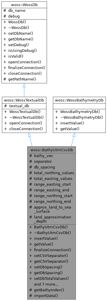
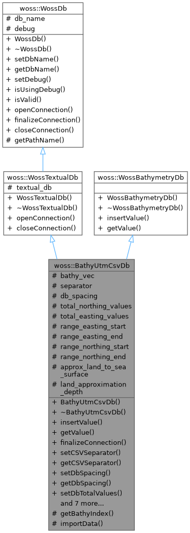
Specialization of WossTextualDb for UTM CSV database. More...
#include <bathymetry-utm-csv-db.h>


Public Member Functions | |
| BathyUtmCsvDb (const ::std::string &name) | |
| virtual bool | insertValue (const Coord &coordinates, const Bathymetry &bathymetry_value) |
| virtual double | getValue (const Coord &coords) const |
| virtual bool | finalizeConnection () |
| void | setCSVSeparator (const char new_separator) |
| const char | getCSVSeparator () const |
| void | setDbSpacing (double spacing) |
| double | getDbSpacing () const |
| void | setDbTotalValues (int nnorth, int neast) |
| std::pair< int, int > | getDbTotalValues () const |
| void | setDbRangeEasting (double start, double end) |
| std::pair< double, double > | getDbRangeEasting () const |
| void | setDbRangeNorthing (double start, double end) |
| std::pair< double, double > | getDbRangeNorthing () const |
| void | setLandApproximationFlag (bool flag) |
| bool | getLandApproximationFlag () |
 Public Member Functions inherited from woss::WossTextualDb Public Member Functions inherited from woss::WossTextualDb | |
| WossTextualDb (const ::std::string &name) | |
| virtual bool | openConnection () |
| virtual bool | closeConnection () |
 Public Member Functions inherited from woss::WossDb Public Member Functions inherited from woss::WossDb | |
| WossDb (const ::std::string &name) | |
| void | setDbName (const ::std::string &pathname) |
| ::std::string | getDbName () const |
| void | setDebug (double flag=true) |
| bool | isUsingDebug () const |
| virtual bool | isValid () |
Protected Member Functions | |
| int | getBathyIndex (const Coord &coords) const |
| virtual bool | importData () |
 Protected Member Functions inherited from woss::WossDb Protected Member Functions inherited from woss::WossDb | |
| PathName | getPathName (const ::std::string &complete_path) |
Protected Attributes | |
| std::vector< double > | bathy_vec |
| char | separator |
| double | db_spacing |
| int | total_northing_values |
| int | total_easting_values |
| double | range_easting_start |
| double | range_easting_end |
| double | range_northing_start |
| double | range_northing_end |
| bool | approx_land_to_sea_surface |
 Protected Attributes inherited from woss::WossTextualDb Protected Attributes inherited from woss::WossTextualDb | |
| ::std::fstream | textual_db |
 Protected Attributes inherited from woss::WossDb Protected Attributes inherited from woss::WossDb | |
| ::std::string | db_name |
| bool | debug |
Static Protected Attributes | |
| static const double | land_approximation_depth = 0.000000001 |
Detailed Description
Specialization of WossTextualDb for UTM CSV database.
Specialization of WossTextualDb for UTM CSV database. It creates a vector used to get requested bathymetry values.
Constructor & Destructor Documentation
◆ BathyUtmCsvDb()
| BathyUtmCsvDb::BathyUtmCsvDb | ( | const ::std::string & | name | ) |
BathyUtmCsvDb constructor
- Parameters
-
name pathname of database
Member Function Documentation
◆ finalizeConnection()
|
virtual |
Post openConnection() actions. It create and initializes a NetCDF variable
- Returns
- true if method was successful, false otherwise
Implements woss::WossDb.
References importData().

◆ getBathyIndex()
|
protected |
Returns the index corresponding the given coordinates. This index will be used to access the vector variable and thus retrieving the bathymetry value
- Parameters
-
coords const reference to a valid Coord object
- Returns
- index value
References db_spacing, woss::WossDb::debug, woss::UtmWgs84::getUtmWgs84FromCoord(), range_easting_end, range_easting_start, range_northing_end, range_northing_start, and total_easting_values.
Referenced by getValue().

◆ getCSVSeparator()
|
inline |
◆ getDbRangeEasting()
|
inline |
Returns the current db range easting
- Returns
- the db easting range start and end
References range_easting_end, and range_easting_start.
◆ getDbRangeNorthing()
|
inline |
Returns the current db range northing
- Returns
- the db easting range start and end
References range_northing_end, and range_northing_start.
◆ getDbSpacing()
|
inline |
Returns the current db spatial resolution
- Returns
- the db spatial resolution in meters
References db_spacing.
◆ getDbTotalValues()
|
inline |
Returns the total northing and easting values
- Returns
- pair of total northing and easting values
References total_easting_values, and total_northing_values.
◆ getLandApproximationFlag()
|
inline |
Returns the current land approximation flag
- Returns
- the land approximation flag
References approx_land_to_sea_surface.
◆ getValue()
|
virtual |
Returns the positive depth value ( bathymetry ) of given coordinates, if present in the database. If given coordinates are on land ( original retrieved value is positive ) HUGE_VAL is returned.
- Parameters
-
coords const reference to a valid Coord object
- Returns
- positive depth value [m] if coordinates are found, HUGE_VAL otherwise
Implements woss::WossBathymetryDb.
References approx_land_to_sea_surface, bathy_vec, woss::WossDb::debug, getBathyIndex(), and land_approximation_depth.

◆ importData()
|
protectedvirtual |
Imports data from .csv file and store depth values in the bathy_vec
- Returns
- true if operation succeeds, false otherwise
References bathy_vec, woss::WossDb::db_name, woss::WossDb::debug, separator, and woss::WossTextualDb::textual_db.
Referenced by finalizeConnection().
◆ insertValue()
|
virtual |
Inserts the given woss::Bathymetry value in the database for given coordinates
- Parameters
-
coordinates const reference to a valid Coord object bathymetry_value const reference to woss::Bathymetry value to be inserted
- Returns
- true if method was successful, false otherwise
Implements woss::WossBathymetryDb.
◆ setCSVSeparator()
|
inline |
Sets the char separator used in CSV textual db
- Parameters
-
new_separator separator char
References separator.
Referenced by woss::BathyUtmCsvDbCreator::createWossDb().
◆ setDbRangeEasting()
|
inline |
Sets db range easting start and end
- Parameters
-
start easting range start end easting range end
References range_easting_end, and range_easting_start.
Referenced by woss::BathyUtmCsvDbCreator::createWossDb().
◆ setDbRangeNorthing()
|
inline |
Sets db northing range start and end
- Parameters
-
start northing range start end northing range end
References range_northing_end, and range_northing_start.
Referenced by woss::BathyUtmCsvDbCreator::createWossDb().
◆ setDbSpacing()
|
inline |
Sets db resolution, in meters
- Parameters
-
spacing space resolution in meters
References db_spacing.
Referenced by woss::BathyUtmCsvDbCreator::createWossDb().
◆ setDbTotalValues()
|
inline |
Sets the db total northing and easting values
- Parameters
-
nnorth db total northing points. should be >= 0 neast db total easting points. should be >= 0
References total_easting_values, and total_northing_values.
Referenced by woss::BathyUtmCsvDbCreator::createWossDb().
◆ setLandApproximationFlag()
|
inline |
Sets land approximation flag
- Parameters
-
flag land approximation flag
References approx_land_to_sea_surface.
Referenced by woss::BathyUtmCsvDbCreator::createWossDb().
Member Data Documentation
◆ approx_land_to_sea_surface
|
protected |
Approximate land db points to sea surface
Referenced by getLandApproximationFlag(), getValue(), and setLandApproximationFlag().
◆ bathy_vec
|
protected |
Vector with bathymetry values
Referenced by getValue(), and importData().
◆ db_spacing
|
protected |
spatial spacing of the db, in meters
Referenced by getBathyIndex(), getDbSpacing(), and setDbSpacing().
◆ land_approximation_depth
|
staticprotected |
Depth value for land approximation
Referenced by getValue().
◆ range_easting_end
|
protected |
Separator used in the csv file
Referenced by getBathyIndex(), getDbRangeEasting(), and setDbRangeEasting().
◆ range_easting_start
|
protected |
Separator used in the csv file
Referenced by getBathyIndex(), getDbRangeEasting(), and setDbRangeEasting().
◆ range_northing_end
|
protected |
Separator used in the csv file
Referenced by getBathyIndex(), getDbRangeNorthing(), and setDbRangeNorthing().
◆ range_northing_start
|
protected |
Separator used in the csv file
Referenced by getBathyIndex(), getDbRangeNorthing(), and setDbRangeNorthing().
◆ separator
|
protected |
Separator used in the csv file
Referenced by getCSVSeparator(), importData(), and setCSVSeparator().
◆ total_easting_values
|
protected |
Separator used in the csv file
Referenced by getBathyIndex(), getDbTotalValues(), and setDbTotalValues().
◆ total_northing_values
|
protected |
Separator used in the csv file
Referenced by getDbTotalValues(), and setDbTotalValues().
The documentation for this class was generated from the following files:
- woss/woss_db/bathymetry-utm-csv-db.h
- woss/woss_db/bathymetry-utm-csv-db.cpp